Top 3


Transportation and Urban Form
Take advantage of the market shift away from traditional retail and towards e-commerce in order to promote mixed-use land development; convert over-retailed areas into places that include a variety of land uses (office, retail, housing, etc.)
As online retailers become more prevalent, convenient, and popular the demand for certain brick-and-mortar stores will decline, leaving old retail space available for redevelopment.
Tool: Encourage the adoption of form-based codes in appropriate locations and centers.
Form-based codes are attractive because they can provide development and permitting incentives that current development standards don’t offer. Form based codes focus on regulating the physical form of buildings and development rather than on separating land uses. a Form-based codes also encourage compact, mixed-use development which results in more biking and walking opportunities.
[i]
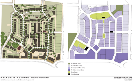
This illustration from Mackenzie Meadows, British Columbia shows a visualization of what a form based code plan might look like.
Resources
- Form-Based Codes Institute website
http://formbasedcodes.org/ - Center for Applied Transect Studies website
http://transect.org/codes.html
Tool: Develop pedestrian-oriented overlay districts.
Pedestrian zones encourage the development of pedestrian friendly commercial districts. Residents should be able to access services conveniently without having to drive.. Districts require commercial uses at the ground floor that cater to pedestrians. Districts also have lower parking requirements and limited driveways in order to encourage new development that gives priority to pedestrian friendly streetscapes.
Resource
- Pedestrian overlay zones in the Seattle Land Use Code http://www.seattle.gov/Transportation/pedestrian_masterplan/pedestrian_toolbox/tools_pluz_zoning.htm
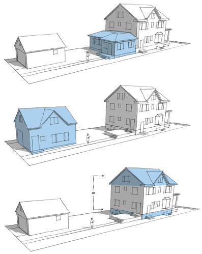
Tool: Allow accessory dwelling units in all residential zones.
Accessory dwelling units provide alternatives to housing, increase affordable housing options, and create density in existing neighborhoods.
[ii]
Above are three different kinds of Accessory Dwelling Units, in blue.
Resources
- American Planners Association Quicknotes: Accessory Dwelling Units
https://www.planning.org/pas/quicknotes/pdf/QN19.pdf - AARP Accessory Dwelling Units: Model State Act and Local Ordinance
http://assets.aarp.org/rgcenter/consume/d17158_dwell.pdf
Encourage higher density and transit-oriented development, smaller block sizes, and higher density of intersections.
People are more likely to use active and public transportation if there are small blocks, a high number of street intersections, and high residential densities. These improvements to the urban environment influence travel behavior and can result in reduced emissions from vehicles by reducing trip distances and frequency.
Tool: Promote a maximum block length of 400’.
Requiring new developments to have block sizes below 400’ increases pedestrian connectivity and allows for more mobility for cyclists and pedestrians. Traffic capacity also increases when a community has more connected street networks. Large block sizes do not facilitate active transportation.
Resource
- Measuring Network Connectivity for Bicycling and Walking: http://reconnectingamerica.org/assets/Uploads/TRB2004-001550.pdf
Tool: Require mid-block crossings on longer blocks.
Midblock crossings allow people to travel to places that are otherwise not served by the existing pedestrian network. If formal crossings are too far apart, pedestrians will illegally cross the street rather than walk to the next intersection. Mid-block crossings increase pedestrian and bicyclist comfort and safety.
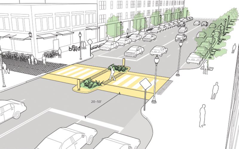
[iii]
Resource
- NACTO Urban Street Design Guide: http://nacto.org/publication/urban-street-design-guide/intersection-design-elements/crosswalks-and-crossings/midblock-crosswalks/
Tool: Require a connectivity index for new streets. Indexes
A Connectivity Index can be used to quantify how well a roadway network connects destinations. While a traditional Connectivity Index measures motorized transportation networks, other indexes take into account non-motorized shortcuts, such as paths that connect cul-de-sacs, and barriers such as highways and roads that lack sidewalks.
Resource
- Roadway Connectivity from the Victoria Transport Policy Institute
http://www.vtpi.org/tdm/tdm116.htm
Tool: Encourage transit-oriented development.
Transit-oriented developments (TOD) encourage moderate and high density housing near a transit site. TOD’s create an environment that is conducive to walking, biking, and using public transit. TOD’s see reduced traffic congestion and accidents and expanded mobility for cyclists and pedestrians.
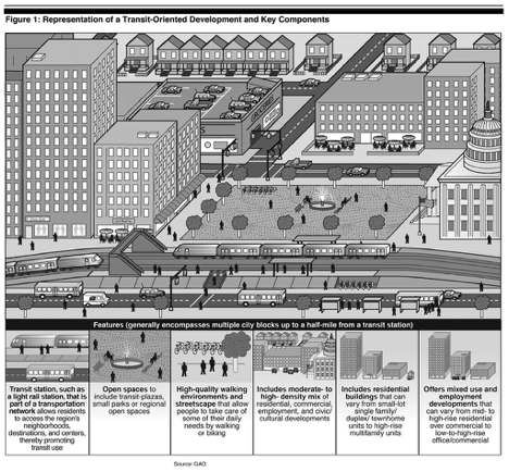 [iv]
[iv]
Resources
- An introduction to transit-oriented development. http://www.reconnectingamerica.org/what-we-do/what-is-tod
Organize and zone well-spaced, walkable community centers.
Historically, Utah was planned around a network of close-knit communities up and down the Wasatch Front. This pattern of centers brought important destinations close to residents in the pre-automobile age. Building on this network and expanding it in greenfield areas is critical to shortening and eliminating vehicle trips. Commercial, civic, religious, retail, and educational centers built around existing cores, and planned in future core areas, will bring daily needs within walking distance of most people.
Tool: Identify appropriate node locations and size to create “20 minute neighborhoods.”
Walkable districts usually have nodes between ¼ and ½ of a mile wide. Smaller commercial centers provide more bicycle and pedestrian access.
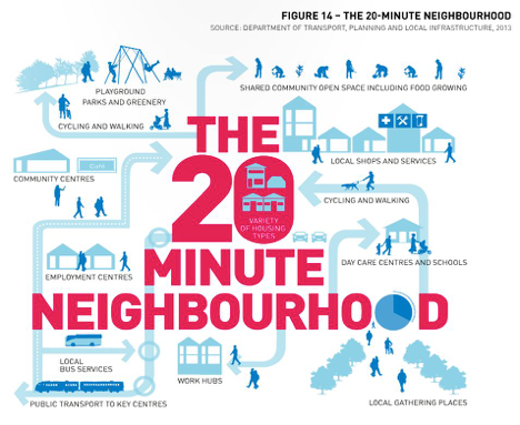
[v]
Tool: Rezone underutilized commercial property between nodes to other uses.
Economic development can be fostered through the rezoning of underutilized commercial property. This capitalizes on market trends of a shift from traditional brick and mortar stores to online retail and warehouses. As store spaces become available, they can be repurposed for other uses and preserved as centers, and provide adequate access for the neighborhoods they serve.
Tool: Minimize the amount of parking required by new development.
By eliminating minimum parking requirements both land and money could be freed up for better uses. The construction, maintenance, and land costs associated with providing free or subsidized parking could be used to fund more energy-efficient forms of transportation than driving, like public transportation.
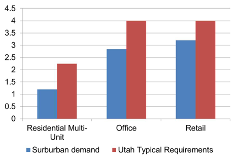
[vi]
The above graph shows required versus needed parking spaces for residences per-unit, and required versus needed parking spaces for office and retail per 1000 square feet of building space.
Case Studies
- Lower parking requirements, California. California passed legislation in October, 2015, “which allows affordable housing developers to build less parking than many local zoning regulations currently permit.” Affordable housing advocates have long claims that burdensome parking requirements have made affordable housing too expensive to build. http://cal.streetsblog.org/2015/10/12/governor-brown-signs-bill-loosening-parking-requirements-for-affordable-housing/
- Market-driven parking supply, Arkansas. The city of Fayettville, Arkansas, adopted a change to the parking code that completely eliminated minimum parking requirements for nonresidential properties. This allows businesses to consider their parking needs based on market demand, rather than city code requirements. http://www.fayettevilleflyer.com/2015/10/07/fayetteville-eliminates-minimum-parking-requirements/
Improve transit ridership through increased accessibility.
Making it more convenient for Provo residents to access public transit will result in a decrease of private vehicular use and the associated emissions which pollute our air.
Tool: Prioritize bicycle and pedestrian routes near and around transit stops.
Bicycle and pedestrian routes near transit stops provide a non-motorized way to move between the transit stop and final destination. Public transit users may also increase with the addition of bicycle and pedestrian routes because people who would otherwise find public transit inconvenient may use it in combination with biking and walking.
Resource
- Federal resources available to local transit operation and capital projects including improvements to bicycle and pedestrian access. http://www.fta.dot.gov/documents/FINAL_FTA_circular9030.1E.pdf
Promote urban forestry and gardening on city lands and in neighborhoods.
Plants naturally filter our air and provide us with oxygen. They also provide additional benefits of beautifying neighborhoods, improving walkability, and providing shade to offset summer cooling costs.
Tool: Encourage green roofs.
Green roofs insulate buildings and help filter the air. This reduces building heating and cooling costs, while reducing emissions, absorbing some emissions, and also filtering storm water runoff.
Case Study
- Green roofs, Toronto, Canada. The city’s Green Roof Bylaw requires green roofs on commercial, institutional, and many residential buildings. http://www1.toronto.ca/wps/portal/contentonly?vgnextoid=3a7a036318061410VgnVCM10000071d60f89RCRD
Tool: Form an organization to increase the number of trees in Provo.
An organization whose purpose is to increase the number of trees in our urban forest could help individuals and neighborhoods access funding for purchasing trees.
Resource
- Street trees clean the air, increase property values, and make neighborhoods more walkable. http://www.nfs.unl.edu/documents/communityforestry/urbanforestvalues.pdf
Case Study
- Friends of the Urban Forest, San Francisco. Friends of the Urban Forest (FUF) is a non-profit that provides trees, technical expertise, and labor for neighborhoods and individuals interested in planting street trees. Since 1981, FUF has planted 47% of San Francisco’s total street tree canopy. http://www.fuf.net/
Create connected, complete, and safe bicycle and pedestrian systems; emphasize navigational simplicity and connecting key neighborhoods, destinations, and transit.
Two important reasons commuters do not use active transportation to get to work or school is because 1) they feel it is unsafe, and 2) the sidewalk and bike lane networks are not continuous or well-maintained. It is important to develop complete alternative transportation networks in order for them to be useful and used by commuters.
Tool: Adopt a “Complete Streets” approach and philosophy that all streets and development on streets be designed and operated to enable safe access for all users, ages, and abilities.
Complete streets are designed with all users in mind (drivers, transit riders, pedestrians, bicyclists, the elderly, children, and people with disabilities). This encourages alternative forms of transportation which will help clear our air.
Resources
- An introduction to Complete Streets. http://www.smartgrowthamerica.org/complete-streets
- Complete Streets Local Policy Workbook. http://www.smartgrowthamerica.org/documents/cs-local-policy-workbook.pdf
Case Study
- Complete Streets, Salt Lake City. Salt Lake City adopted a Complete Streets ordinance in 2010. The City’s second annual bicycle count reveals exciting results. After investing in approximately 50 lane miles of on-street bicycle facilities, the number of people riding bikes is up 27% over last year’s count. [vii] http://www.bikeslc.com/GetInvolved/MasterPlansandPolicies/PDF/CompleteStreetsOrdinance.pdf
Tool: Develop bicycle parking requirements including long-term bike parking.
Bicycle parking minimizes the hassle and inconvenience of searching for a secure and safe place to lock one’s bicycle when arriving at one’s destination. By eliminating inconvenience and barriers, bicycle parking can elevate bicycling towards becoming a legitimate and viable transportation option for most trips in Provo. Thorough bicycle parking requirements account for both short-term and long-term parking, promote proper siting and layout, and allow for conversion of vehicular parking to bicycle parking.
Resource
- The Association of Pedestrian and Bicycle Professionals Bicycling Parking Guidelines: http://www.apbp.org/?page=publications
Case Studies
- Bicycle Parking Requirements, Salt Lake City
http://bikeslc.com/GetInvolved/MasterPlansandPolicies/Required%20Bicycle%20Parking.html - Bicycle Parking Ordinance, San Francisco
http://www.sfbos.org/ftp/uploadedfiles/bdsupvrs/ordinances13/o0183-13.pdf
Tool: Encourage employers to provide end of trip facilities (such as changing rooms or showers) for bicyclists and pedestrians in dense employment areas.
Commuters who bicycle or walk to work can often arrive wet, muddy or sweaty. In order to make walking or cycling to work viable for many employees, showers and changing facilities (either on-site or close to work) are a necessary amenity.
Resources
- LEED Requirements for Showers and Changing Facilities.
Many LEED certifications include requirements for showers and changing facilities.
http://www.usgbc.org/node/2614413?return=/credits/new-construction/v4 - Article on the importance of providing showers for commuters who bicycle to work. http://www.citylab.com/commute/2012/07/hidden-factor-bike-commuting-showers/2650/
Case Study
- Indy Bike Hub, Indianapolis. The Indy Bike Hub is a partnership between the City of Indianapolis, the YMCA, and Bicycle Garage Indy (a local bike shop). Situated on the Indianapolis Cultural Trail, the Bike Hub provides an ideal location for downtown employees to shower, change and store their bicycles. Other amenities such as a full service bike shop and exercise gym are also present on-site.
http://indybikehub.org/
Tool: Establish a connectivity retrofit plan to address existing developments.
Creating route connections can provide access to many parts of the pedestrian system that would otherwise not be linked. Creating direct routes promotes biking and walking while decreasing vehicle emissions by shortening trip lengths.
Case Study
- Street Connectivity Guidance Document, Lehigh, PA. http://www.lvpc.org/pdf/streetConnectivity.pdf
Tool: Coordinate connectivity of trails, bikeways, and pedestrian facilities.
Connectivity is a key component to making biking and walking convenient. Connectivity standards should include coordination among different departments to encourage connectivity between destinations. New development or redevelopment should require designated bikeways. Street networks should be designed to ensure connectivity for pedestrians and cyclists.
Tool: Require pedestrian connectivity through the end of cul-de-sacs.
Cul-de-sacs often force people to take an unnecessarily long route to their destination because there is no direct access through the end of a cul-de-sac. For example, a child’s school may be within 100 yards of their home (as the crow flies), but instead of walking to school, children must be driven half a mile in a car because their street dead-ends.
[viii]
Case Study
- Cul-de-sac connections, California. Davis, California, requires that cul-de-sacs connect bicycle/pedestrian corridors. “Davis streets shall be connected with multiple route options for bike and pedestrian travel in new and developed areas. Cul-de-sacs are allowed provided they connect to bicycle/pedestrian corridors.” (from the Davis General Plan) http://cityofdavis.org/home/showdocument?id=4809
Tool: Face buildings and their front doors toward the street
A building’s street-facing façade defines the type of environment on the street. Blank walls (without windows or doors) are uninviting to pedestrians and make them feel as if they are not meant to walk there. Buildings with inviting entrances that allows people passing by to detect active use inside the building encourage walking.
Resource
- Article on how a well-design interface between doors and sidewalks contributes to walkability. http://streets.mn/2014/11/06/front-doors-and-walkable-cities/
Other Key Redevelopment Strategies
Prioritize energy efficiency in new buildings and remodels.
Energy efficient building envelopes, systems, and appliances reduce negative impacts on our air quality while also reducing electricity costs for households and businesses.
Tool: Create a grant program that assists homeowners in installing the best available technologies to attain the highest efficiency in their homes.
Homeowners are demanding more energy efficient homes.[ix] Outfitting homes with the best technologies that will improve air quality will meet that demand and result in savings for Provo homeowners.
Resources
- List of federal and state energy incentive programs that apply in Utah. http://programs.dsireusa.org/system/program?state=UT
- Wattsmart Residential Efficiency Program Rocky Mountain Power https://www.rockymountainpower.net/res/sem/utah.html
- Wattsmart Business Efficiency Program Rocky Mountain Power https://www.rockymountainpower.net/bus/se/utah.html
- Wattsmart New Homes Program Rocky Mountain Power https://www.rockymountainpower.net/res/sem/utah/esnh.html
- ThermWise Business Program http://www.thermwise.com/business/BusinessRebates.php
- Geothermal heat pump tax incentives. http://www.climatemaster.com/commercial-taxes
Case Studies
- High energy ratings and high rents, Australia. NABERS (National Australian Built Environment Rating System. Empirical evidence that higher ratings correspond with higher rents. http://www.nabers.gov.au/public/WebPages/Home.aspx
- Energy efficient elevators, Australia. The 501 Swanston office tower cut its energy bills by 25% by installing elevators that use a regenerative braking system to generate power for the building, “producing energy saving equivalent to removing the carbon emissions of 55 homes a year.” http://www.citylab.com/design/2015/10/what-melbourne-learned-cutting-emissions-from-1200-buildings/410293/?utm_source=SFFB
Develop an RDA sustainability plan with an emphasis on air.
The RDA has a key role to play in cleaning our air, and it has expertise how they can make an impact. Consider the roles you might fulfill in cleaning the air and develop a plan for sustainability with an emphasis on air quality. Develop a method for tracking and measuring progress, and for annual review.
[i] From Better Cities. http://bettercities.net/news-opinion/blogs/howard-blackson/19820/value-visuals
[ii] From City of Minneapolis. http://www.startribune.com/right-to-build-accessory-dwelling-heads-to-minneapolis-council/282303781/
[iii] From NACTO Street Design Guide. http://nacto.org/publication/urban-street-design-guide/intersection-design-elements/crosswalks-and-crossings/midblock-crosswalks/
[iv] From Reconnecting America. https://www.flickr.com/photos/ractod/3953863528
[v] From Plan Melbourne. http://www.planmelbourne.vic.gov.au/Plan-Melbourne
[vi] Data from ITE’s Parking Generation, 3rd Edition 2004. Courtesy of Ted Knowlton, Wasatch Front Regional Council.
[vii] http://www.deseretnews.com/article/705393573/Bike-count-shows-jump-in-cyclists.html
[viii] Pedestrian and bicyclist connectivity from City of Davis, California. http://cityofdavis.org/home/showdocument?id=4809