Top 3


Transportation and Urban Form
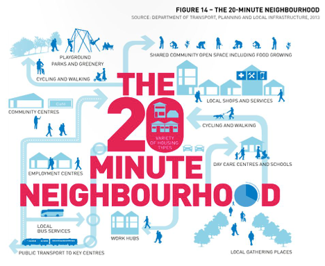
Organize and zone well-spaced, walkable community centers.
Historically, Utah was planned as a network of communities that spread up and down the Wasatch Front. This pattern of centers brought important destinations close to residents in the pre-automobile age. Building on this pattern of centers and expanding it to new green field development is critical to shortening and eliminating vehicle trips. Commercial, civic, religious, retail and educational centers built around existing cores, and planned for future core areas, will bring daily needs within walking distance of most city residents.
Tool: Identify appropriate node locations and size to create “20 minute neighborhoods.”
Commercial nodes can be identified through a community’s master plan. Walkable districts usually have nodes between ¼ and ½ of a mile wide. These small “centers” of activity, commerce, religion, or education are typically no more than one mile apart. The spacing is ideal for making all the services of these nodes accessible on foot or bike.
[i]
Resource
- Introduction to “20 minute neighborhoods.”
http://www.icic.org/connection/blog-entry/blog-the-rise-of-the-20-minute-neighborhood
Tool: Rezone underutilized commercial property between nodes to other uses.
Economic development can be fostered through the rezoning of underutilized commercial property. Rezoning encourages the reuse and revitalization of nodes. This concept capitalizes on market trends of a shift from traditional brick and mortar stores to online retail and warehouses. As brick and mortar store spaces become available, they can be repurposed for other uses, and preserved as centers.
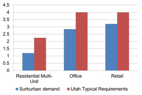
Tool: Reduce new development parking requirements.
Reducing minimum parking requirements frees up both land and money for better uses. The construction, maintenance, and land costs associated with providing free or subsidized parking is a burden on developers and slows down investments in centers.
[ii]
The above graph shows required versus needed parking spaces for residences per-unit, and required versus needed parking spaces for office and retail per 1000 square feet of building space.
Case Studies
- Parking requirement legislation, California. California passed legislation in October, 2015, “which allows affordable housing developers to build less parking than many local zoning regulations currently permit.” Affordable housing advocates have long claims that burdensome parking requirements have made affordable housing too expensive to build. http://cal.streetsblog.org/2015/10/12/governor-brown-signs-bill-loosening-parking-requirements-for-affordable-housing/
- No minimum parking requirement, Arkansas. The City of Fayettville, Arkansas, adopted a change to the parking code that completely eliminated minimum parking requirements for nonresidential properties. This allows businesses to consider their parking needs based on market demand, rather than city code requirements. http://www.fayettevilleflyer.com/2015/10/07/fayetteville-eliminates-minimum-parking-requirements/
Take advantage of market shifts and redevelop over-retailed real estate into higher density, mixed-use housing.
As online retailers become more prevalent and convenient the demand for certain brick-and-mortar stores will decline, leaving old retail space available for redevelopment.
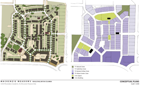
Tool: Adopt a form-based code in appropriate locations and centers.
Form-based codes can provide development and permitting incentives that would make the code more attractive than current development standards. Focusing on the physical forms of buildings and development rather than on separating land uses, a form-based code encourages compact, mixed-use development, which results in more biking and walking opportunities.
[iii]
This illustration from Mackenzie Meadows, British Columbia shows a visualization of what a form based code plan might look like.
Resources
- Form-Based Codes Institute website
http://formbasedcodes.org/ - Center for Applied Transect Studies website
http://transect.org/codes.html - Wasatch Choice for 2040
http://www.envisionutah.org/wasatch-choice-toolbox/tool-form-based-code
Tool: Designate pedestrian-oriented overlay districts.
Pedestrian zones encourage the development of pedestrian friendly commercial districts. Residents should be able to access services without an automobile or with fewer automobile trips. Pedestrian friendly districts require commercial uses at the ground floor, lower parking requirements, limited driveways, and encourage new development that gives priority to walkable and bikeable streetscapes.
Resources
- Pedestrian overlay zones in the Seattle Land Use Code
http://www.seattle.gov/Transportation/pedestrian_masterplan/pedestrian_toolbox/tools_pluz_zoning.htm
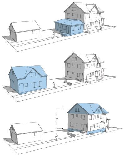
Tool: Allow accessory dwelling units in all residential zones.
Accessory dwelling units provide housing alternatives, increase affordable housing options and increase density in existing neighborhoods.
[iv]
Pictured above are three different types of Accessory Dwelling Units, in blue.
Resources
- American Planners Association Quick notes: Accessory Dwelling Units
https://www.planning.org/pas/quicknotes/pdf/QN19.pdf - AARP Accessory Dwelling Units: Model State Act and Local Ordinance
http://assets.aarp.org/rgcenter/consume/d17158_dwell.pdf
Encourage higher density and transit-oriented development, smaller block sizes, and higher density of intersections.
People are more likely to use active and public transportation if there are small blocks, a high number of street intersections, and higher residential densities. These improvements to the urban environment would influence travel behavior and result in reduced emissions from vehicles by reducing trip distances and frequency.
Tool: Designate transit-oriented development zones in appropriate locations.
Transit-oriented developments (TOD) encourage moderate and high density housing near transit sites. TOD’s create an environment that is conducive to walking, biking and using public transit. TOD’s help reduce traffic congestion, accidents, and expand the mobility of cyclists and pedestrians.
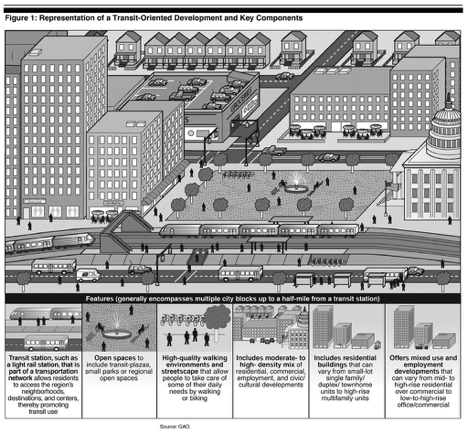
[v]
Resource
- Introduction to Transit-oriented developments http://www.reconnectingamerica.org/what-we-do/what-is-tod/
Tool: Consider a maximum block length of 400’.
Requiring new developments to have block sizes below 400’ increases the pedestrian connectivity and allows for more mobility for cyclists and pedestrians. Traffic capacity also increases when a community has more connected street networks. Large block sizes do not facilitate active transportation.
Resource
- Measuring Network Connectivity for Bicycling and Walking http://reconnectingamerica.org/assets/Uploads/TRB2004-001550.pdf
Tool: Require mid-block crossings on longer blocks.
Midblock crossings allow people to travel to places that are otherwise not served by the existing pedestrian network. If formal crosswalks are too far apart pedestrians will illegally cross the street, rather than walk to the next intersection. Mid-block crossings increase pedestrian and bicyclist comfort and safety.
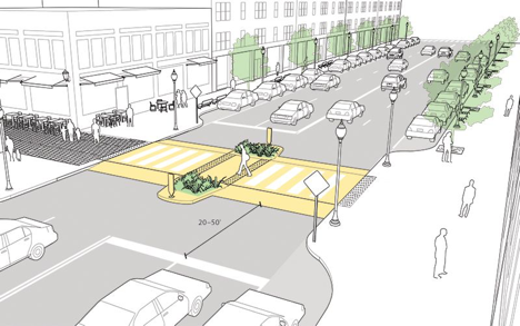
[vi]
Resource
- National Association of City Transportation Officials Urban Street Design Guide:
http://nacto.org/publication/urban-street-design-guide/intersection-design-elements/crosswalks-and-crossings/midblock-crosswalks/
Tool: Require a connectivity index for new streets.
A Connectivity Index can be used to quantify how well a roadway network connects destinations. Indices can be measured separately for motorized and non-motorized travel, taking into account non-motorized shortcuts, such as paths that connect cul-de-sacs, and barriers such highways and roads that lack sidewalks. Several different methods can be used.
Resource
- Roadway Connectivity from the Victoria Transport Policy Institute
http://www.vtpi.org/tdm/tdm116.htm
Improve transit ridership through increased accessibility.
Many people support public transit, but ridership levels depend primarily on the convenience of using transit compared to the convenience of driving a private vehicle. More people will use public transit as it becomes more convenient for them to do so.
Tool: Prioritize bicycle and pedestrian routes near and around transit stops.
Bicycle and pedestrian routes near transit stops help solve “first and last mile” challenges.
Resource
- Report on integrating biking and walking with transit and federal transit funds that can support such programs. http://www.advocacyadvance.org/docs/FirstMileLastMile_August2014_web.pdf
Tool: Conduct a feasibility study for implementing a bike share system in Provo.
Bike share systems can be a powerful tool in improving first mile and last mile connectivity of transit trips. In less dense areas, bike share has shown the ability to expand the reach of transit while in denser areas, bike share has actually replaced some transit trips.
Case Study
- Greenbike, Salt Lake City. Greenbike 2014 Annual Report
https://configuringgreenbike.bcycle.com/docs/librariesprovider32/default-document-library/2014-annual-report.pdf?sfvrsn=2
Tool: Work with UTA for 15-minute trip intervals and protected, well-marked stations.
Decreasing wait times for transit passengers shows a commitment to helping clear our air by reducing private vehicle use.
Create a connected, complete, and safe bicycle and pedestrian system.
One of the reasons commuters do not use active transportation to get to work or school is because they feel it is unsafe, and the sidewalk and bike lane networks are not continuous or well-maintained. It is important to develop complete alternative transportation networks in order for them to be useful and used by commuters. These networks should emphasize connectivity of key neighborhoods, destinations, and transit.
Tool: Adopt a “Complete Streets” policy. Work with UDOT to do the same on state roads.
Complete streets policies direct transportation planners and engineers to consistently design and build streets with all users in mind (drivers, transit riders, pedestrians, bicyclists, the elderly, children, and people with disabilities).
Resources
- Introduction to the National Complete Streets Coalition http://www.smartgrowthamerica.org/complete-streets
- Complete Streets Local Policy Workbook: http://www.smartgrowthamerica.org/documents/cs-local-policy-workbook.pdf
Case Study
- Bicycle Count, Salt Lake City. Salt Lake City adopted a Complete Streets ordinance in 2010.[vii] The City’s second annual bicycle count reveals exciting results. After investing in approximately 50 lane miles of on-street bicycle facilities, the number of people riding bikes is up 27% over last year’s count. http://www.deseretnews.com/article/705393573/Bike-count-shows-jump-in-cyclists.html
Tool: Develop a comprehensive and context-sensitive Urban Street Design Guide that addresses safe crossings, intersections and linear treatments.
State and local roadway design manuals typically focus on the automobile. Newer, revised roadway design manuals that focus on accommodating bicyclists and pedestrians can dramatically improve the streetscape.
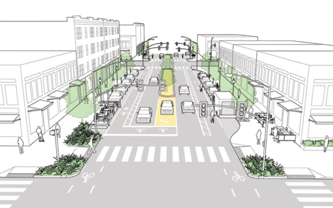
[viii]
Resources
- NACTO Urban Street Design Guide: http://nacto.org/publication/urban-street-design-guide/
- Regional Transportation Commission of Southern Nevada: http://www.rtcsnv.com/wp-content/uploads/2012/06/03-14-13-rtc-Item-26-Complete-Streets-Design-Guidelines.pdf
Tool: Develop bicycle parking requirements including long-term bike parking.
Automobile parking requirements are defined in most city zoning codes and development ordinances. Bicycle parking minimizes the hassle and inconvenience of searching for a secure and safe place to lock a bicycle when arriving at the destination. By eliminating inconvenience and barriers, bicycle parking can elevate bicycling towards becoming a legitimate and viable transportation option for most trips in Provo. Thorough bicycle parking requirements account for both short-term and long-term parking, promote proper siting and layout, and allow for conversion of vehicular parking to bicycle parking.
Resource
- The Association of Pedestrian and Bicycle Professionals Bicycling Parking Guidelines: http://www.apbp.org/?page=publications
Case Studies
- Bicycle Parking Requirements, Salt Lake City.
http://bikeslc.com/GetInvolved/MasterPlansandPolicies/Required%20Bicycle%20Parking.html - Bicycle Parking Ordinance, San Francisco.
http://www.sfbos.org/ftp/uploadedfiles/bdsupvrs/ordinances13/o0183-13.pdf
Tool: Promote end of trip facilities (such as changing rooms or showers) for bicyclists and pedestrians at individual employers or at shared locations in dense employment areas.
Commuters who bicycle or walk to walk can often arrive wet, muddy or sweaty. In order to make walking or cycling to work viable for many employees, showers and changing facilities (either on-site or close to work) are a necessary amenity.
Resource
- LEED Requirements for Showers and Changing Facilities.
http://www.usgbc.org/node/2614413?return=/credits/new-construction/v4
Case Studies
- Indy Bike Hub, Indianapolis. The Indy Bike Hub is a partnership between the City of Indianapolis, the YMCA, and Bicycle Garage Indy (a local bike shop). Situated on the Indianapolis Cultural Trail, the Bike Hub provides an ideal location for downtown employees to shower, change and store their bicycles. Other amenities such as a full service bike shop and exercise gym are also present on-site.
http://indybikehub.org/
Tool: Establish a connectivity retrofit plan to address existing developments.
Some existing neighborhoods are not well-connected to the transportation network. This may be due to current bus routes or bike paths, but more commonly is due to street network design. A retrofit plan would accommodate for future intersections to connect disconnected blocks, linkages through the ends of cul-de-sacs, pedestrian and bike thru-ways, and accommodations for public transit. Creating direct routes promotes biking and walking while it decreases emergency response time and garbage collection costs.
Tool: Require a physical separation between the sidewalk and street such as park strip, on-street parking or paved tree grate area.
Streetscape requirements that provide physical separation between pedestrian, cyclists and automobiles, create a safer, more walkable environment. Street trees provide shade and separation from automobiles and help to calm traffic. On-street parking and parked cars provide a buffer for cyclists and pedestrians.
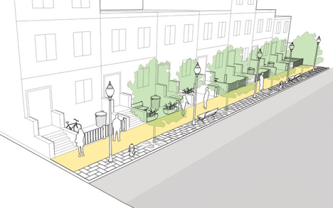
[ix]
Resource
- NACTO Urban Street Design Guide: http://nacto.org/publication/urban-street-design-guide/
Tool: Maintain an up-to-date bicycle and pedestrian master plan to coordinate connectivity of trails, bikeways and pedestrian facilities.
Maintaining an up-to-date master plan helps to ensure pedestrian friendly policies and design within future development. Updating the City’s master plan allows them to build on past successes while developing a future guide for new visions and policies. Provo currently has a Bicycle Master Plan which was adopted in September of 2013. The City should also consider developing a Pedestrian Master Plan to complement the existing Bicycle Master Plan.
Resource
- Utah Bicycle and Pedestrian Master Plan Design Guide
http://www.choosehealth.utah.gov/documents/pdfs/Utah_Bike_Ped_Guide.pdf
Tool: Provide lighting along streets, trails and public spaces to promote safety.
The use of appropriate lighting along sidewalks, crosswalks and public spaces creates a safer and more comfortable environment for cyclists and pedestrians. Pedestrian scale lighting promotes safety through traffic calming and illuminated bikeways discourage criminal activity. People are encouraged to bike and walk more when they feel safe, especially at night.
Resource
- Seattle Pedestrian Lighting Citywide Plan
http://www.seattle.gov/transportation/pedestrian_masterplan/docs/PedLightingFINAL.pdf
Tool: Require pedestrian connectivity through the end of cul-de-sacs.
Cul-de-sacs often force people to take an unnecessarily long route to their destination because there is no direct access through the end of a cul-de-sac. For example, a child’s school may be within 100 yards of their home (as the crow flies), but instead of walking to school, they are driven in a car because of the limited connectivity.
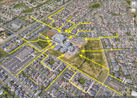 Above is a good example of neighborhood connectivity to a local school.
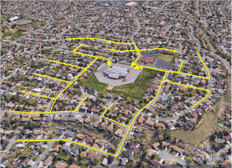 Above is a poor example of neighborhood connectivity to a local school.
Case Study
- Cul-de-sac connections, California. Davis, California, requires that cul-de-sacs connect bicycle/pedestrian corridors. “Davis streets shall be connected with multiple route options for bike and pedestrian travel in new and developed areas. Cul-de-sacs are allowed provided they connect to bicycle/pedestrian corridors.” (from the Davis General Plan)
http://cityofdavis.org/home/showdocument?id=4809
Tool: Develop a comprehensive wayfinding system for bicyclists and pedestrians.
Bicycle and pedestrian wayfinding signage provides the same navigational infrastructure for pedestrians as we do for vehicle traffic on freeways. This would encourage people to use active transportation by facilitating pathway finding and helps to make foot and bike traffic feel as important as vehicular traffic.
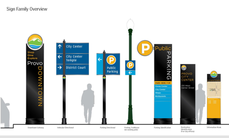 [x]
[x]
Case Study
- Legible London wayfinding system, England. http://content.tfl.gov.uk/legible-london-evaluation-summary.pdf
Ensure that active transportation is measured and appropriately valued within overall transportation planning metrics.
Accounting for active transportation in transportation planning is a prerequisite to achieving a goal of increasing active transportation.
Tool: Develop an annual report describing active transportation metrics.
Tracking significant active transportation criteria including commute to work mode share, funds invested in facilities and programs, number of miles of facilities constructed, collision and health data can help to track the benefits of bicycling and walking within a community.
Resource
- San Francisco Bicycle Coalition: https://www.sfbike.org/wp-content/uploads/2014/04/Annual-Report-2013-web.pdf
Tool: Develop a comprehensive bicycle and pedestrian counting methodology to track progress and quantify benefits.
Counting methodology that observes the behavior of cyclists and pedestrians can help secure bicycling and walking amenities and help to prioritize infrastructure improvements.
Case Studies
- Manual Count Program in Seattle, Washington http://www.downtownseattle.com/resources/pedestrian-counts/
- Automatic Count Program in Arlington County, Virginia http://departments.arlingtonva.us/des
Tool: Use metrics beyond vehicular LOS to assess new roadway projects.
Tools such as Multi-modal Level of Service (MMLOS), Bicycle level of service (BLOS) or Pedestrian level of service (PLOS) can be used to track the success of new roadway projects.
Tool: Develop safe routes to school for children.
Partner schools with the Utah Department of Transportation to develop safe routes for children to bike and walk to and from school on developed bike lanes and sidewalks with monitored crosswalks.
Resource
- Safe Routes to School National Partnership report on promoting active transportation http://www.saferoutespartnership.org/sites/default/files/pdf/The_Final_Active_Primer.pdf
Reconsider parking requirements in order to promote alternative forms transportation.
Some building requirements distort real estate markets and subsidize automobile traffic. Current minimum parking requirements and “free” parking both force developers and business owners to subsidize driving habits. They also use up land that would otherwise be free for higher value uses. Consider advocating for ordinances which allow the market to determine driving and reduce instances of cars parked and idling.
Tool: Reduce new development parking requirements.
Reducing minimum parking requirements frees up both land and money for better uses. The construction, maintenance, and land costs associated with providing free or subsidized parking is a burden on developers and slows down investments in centers.

[xi]
The above graph shows required versus needed parking spaces for residences per-unit, and required versus needed parking spaces for office and retail per 1000 square feet of building space.
Case Studies
- Parking requirement legislation, California. California passed legislation in October, 2015, “which allows affordable housing developers to build less parking than many local zoning regulations currently permit.” Affordable housing advocates have long claims that burdensome parking requirements have made affordable housing too expensive to build. http://cal.streetsblog.org/2015/10/12/governor-brown-signs-bill-loosening-parking-requirements-for-affordable-housing/
- No minimum parking requirement, Arkansas. The City of Fayettville, Arkansas, adopted a change to the parking code that completely eliminated minimum parking requirements for nonresidential properties. This allows businesses to consider their parking needs based on market demand, rather than city code requirements. http://www.fayettevilleflyer.com/2015/10/07/fayetteville-eliminates-minimum-parking-requirements/
Tool: Allow parking pricing to represent true costs.
“Free” parking encourages excessive driving, which pollutes our air and ends up costing us money in healthcare and lost productivity. UCLA Urban Planning Professor Donald C. Shoup estimates that the value of the free-parking subsidy to cars was at least $127 billion in the U.S. in 2002.[xii]
Resource
- “Free Parking Comes at a Price”, Tyler Cowen, The New York Times http://www.nytimes.com/2010/08/15/business/economy/15view.html?_r=0
Develop stronger anti-idling messaging/signage, or even bans in problem areas.
Stronger anti-idling messaging can help reduce emissions, areas like drive-throughs, schools drop-off zones, and truck stops are especially susceptible to emission spikes from idling.
Case Studies
- Anti-idling laws, Salt Lake City. Salt Lake City currently has anti-idling laws, where within city limits, it is illegal to idle a vehicle. In Utah, the Idle Free campaign has partnered with 65 schools that now have signage to remind parents and visitors to turn their engines off. Since 2010, when Governor Gary R. Herbert declared September Idle Free Awareness Month, over 35 mayors and 300 schools have joined the effort to be Idle Free. Individuals can pick up free window stickers to spread the message about Idle Free Utah, and organizations can also pick up signs to be put outside in their parking lots to mark idle free zones. http://utahcleancities.org/idlefree-utah
Area Sources
Encourage the state to implement the most current building code standards and implement higher building code standards locally with state approval.
Legislation in favor of energy efficient buildings would reduce the supply of buildings that negatively impact our air quality.
Tool: Encourage installation of high efficiency, low emissions appliances.
There is a notable difference between the output of a low NOx water heater and an ultra-low NOx water heater. Although ultra-low NOx water heaters tend to be less energy efficient, various design techniques can be used to increase the water heater efficiency to meet the Energy Star criteria (2013 California Building Energy Efficiency Standards, p. 14). Most Ultra-low NOx water heaters cost about $70 more than the low NOx, and $150 more for Energy Star rated models.
Case Studies
- Legislation for low NOx water heaters, Texas. https://www.tceq.texas.gov/assets/public/legal/rules/hist_rules/Complete.04s/04076117/04076117_ado_clean.pdf
- Commercial Building Disclosure (CBD) Program, Australia. The CBD Program established in Australia “requires energy efficiency information to be provided in most cases when commercial office space of 2000 square meters or more is offered for sale or lease. An informed market rewards better performing buildings. It creates a strong market-based incentive for owners to improve their properties with cost-effective energy efficient upgrades that are attractive to buyers and tenants and increase return on investment.” http://cbd.gov.au/overview-of-the-program/what-is-cbd#Q3
Promote urban forestry and gardening on city lands, and in neighborhoods.
Plants naturally filter our air and provide us with oxygen. They also provide additional benefits of beautifying neighborhoods, improving walkability, and providing shade to offset summer cooling costs.
Tool: Encourage green roofs.
Green roofs insulate buildings, help absorb some emissions, and add to the visual interest and beauty of urban areas. This reduces building heating and cooling costs, while reducing emissions, and also filtering storm water runoff.
Case Study
- Green roofs, Toronto, Canada. The city’s Green Roof Bylaw requires green roofs on commercial, institutional, and many residential buildings. http://www1.toronto.ca/wps/portal/contentonly?vgnextoid=3a7a036318061410VgnVCM10000071d60f89RCRD
Tool: Form an organization to increase the number of trees in Provo.
An organization whose purpose is to increase the number of trees in our urban forest could help individuals and neighborhoods access funding for purchasing trees.
Resource
- Street trees clean the air, increase property values, and make neighborhoods more walkable. http://www.nfs.unl.edu/documents/communityforestry/urbanforestvalues.pdf
Case Study
- Friends of the Urban Forest, San Francisco. Friends of the Urban Forest (FUF) is a non-profit that provides trees, technical expertise, and labor for neighborhoods and individuals interested in planting street trees. Since 1981, FUF has planted 47% of San Francisco’s total street tree canopy. http://www.fuf.net/
Other
Promote the use of alternative fuel sources.
The availability of alternative fuel sources in our cities is one of the largest factors determining their success. Electric vehicle charging stations, CNG stations, and other alternative fueling stations situated throughout the city ensures that these lower-emission alternatives to gasoline are used. The planning commission can take this into account as they make plans for future land use and future utilities.
Tool: Improve the network of electric automobile charging stations.
In recent years, electric vehicle sales have jumped tremendously. In 2014, approximately 119,710 electric vehicles were sold in the United States in 2014, representing a 23% increase from 2013 and a 128% from 2012.[xiii] Although electric vehicle sales represented less than one percent of car sales in 2014, in just a few years, their availability, reliability, and affordability has greatly increased and should continue to do so.
Case Study
- Charging station at local business, Salt Lake City. Utah Paperbox (UPB) installed five electric vehicle charging stations. UPB worked in a partnership with Utah Clean Cities and received American Recovery and Reinvestment Act funding to support the station installation.
http://www.afdc.energy.gov/case/1569
Tool: Improve network of alternative fuels available (CNG, EG).
By expanding the infrastructure for alternative fuels, they become feasible alternatives for gasoline and diesel. Accessibility should be promoted in city planning initiatives.
Resources
- Alternative Fueling Station Counts by State
http://www.afdc.energy.gov/fuels/stations_counts.html - Alternative Fuel Infrastrcture Expansion report from the U.S. Department of Energy
http://www.nrel.gov/docs/fy13osti/55640.pdf
Develop a Planning Commission Sustainability Plan with an emphasis on air.
The Planning Commission has a key role to play in cleaning our air, and it has expertise how to make an impact. Consider the roles you might fulfill in cleaning the air and develop a departmental plan for sustainability with an emphasis on air quality. Develop a method for tracking and measuring progress, and a process for annual review.
[i] From Plan Melbourne. http://www.planmelbourne.vic.gov.au/Plan-Melbourne
[ii] Data from ITE’s Parking Generation, 3rd Edition 2004. Courtesy of Ted Knowlton, Wasatch Front Regional Council
[iii] From Better Cities. http://bettercities.net/news-opinion/blogs/howard-blackson/19820/value-visuals
[iv] From the city of Minneapolis. http://www.startribune.com/right-to-build-accessory-dwelling-heads-to-minneapolis-council/282303781/
[v] Image from Reconnecting America. https://www.flickr.com/photos/ractod/3953863528
[vi] From NACTO Street Design Guide. http://nacto.org/publication/urban-street-design-guide/intersection-design-elements/crosswalks-and-crossings/midblock-crosswalks/
[vii] http://www.bikeslc.com/GetInvolved/MasterPlansandPolicies/PDF/CompleteStreetsOrdinance.pdf
[viii] From NACTO Street Design Guide. http://nacto.org/publication/urban-street-design-guide/streets/neighborhood-main-street
[ix] From NACTO Street Design Guide. http://nacto.org/publication/urban-street-design-guide/street-design-elements/sidewalks
[x] From Mayor Curtis’ Provo Insider website. http://provomayor.com/2013/05/07/way-finding-signs/
[xi] Data from ITE’s Parking Generation, 3rd Edition 2004. Courtesy of Ted Knowlton, Wasatch Front Regional Council.
[xii] http://www.nytimes.com/2010/08/15/business/economy/15view.html?_r=0
[xiii] http://fortune.com/2015/01/08/electric-vehicle-sales-2014/